By: Colin David and Tal Beeri
General:
The Iranian medium and long-range ballistic missile array constitutes a significant strategic threat. While it is clear that Iran must not be allowed to possess an existential threat capability such as a nuclear bomb or military-grade uranium enrichment, it is also unacceptable for a country with an extremist Islamic ideology—that advocates exporting the Islamic Revolution worldwide and the physical destruction of the State of Israel—to additionally hold a significant strategic threat capability in the form of medium and long-range ballistic missiles.
Any solution, whether military or diplomatic (agreement), must include effective mechanisms to remove the ballistic missile threat.
The purpose of this report is to assess the battle damage (BDA) and the scope of reconstruction at 25 primary launch missile bases in Iran, which, according to assessments, possess capabilities for strikes using medium-range ballistic missiles.
A medium-range ballistic missile is defined as having a maximum range of between 1,000 and 3,000 kilometers, in accordance with the definition of the United States Department of Defense.
Of the 25 bases detailed in this report, 19 were directly attacked during the war against Iran in June 2025 (6 of the bases were not attacked at all).
It should be noted that in June 2025, additional smaller military sites related to the ballistic missile program were also attacked. However, it was determined that they do not include launch capabilities for medium-range ballistic missiles and therefore are not included in the presented list. Larger ballistic missile facilities with the sole purpose of ballistic missile production and not operations, such as Shahroud (شاهرود) or Khojir (خجیر), are also not included in the presented list.
The damage assessment was conducted through analysis of satellite imagery, including Sentinel-2 L2A and Landsat data collected between June 11, 2025, and June 27, 2025. The scopes of reconstruction were examined through analysis of Airbus, Sentinel-2 L2A, and Landsat imagery collected between August 2025 and January 2026.
Key Findings:
In our assessment, the damage caused above ground to Iran’s ballistic missile infrastructure during the war in June 2025 only temporarily rendered the large missile launch bases inoperable operationally.
All the military launch bases detailed in this report include underground infrastructure. These infrastructures create an effective problem for the attacking munitions in terms of penetration capability. Therefore, we assess that any Iranian asset, system, or infrastructure located within these underground infrastructures survived the 12 days of war.
As of the end of January 2026, it appears that the large launch bases, which sustained moderate to heavy above-ground damage, show clear signs of reconstruction and continued operational activity. In contrast, reconstruction efforts at the smaller attacked bases are almost imperceptible. The significant strategic threat posed by medium and long-range ballistic missiles has not been removed. Iran is vigorously working to restore it.
Below is a breakdown of the 25 launch bases, categorized by damage assessment and scope of reconstruction:
(Note: Bases are named after the locality in close proximity to their location. Exact location of each base can be found in the provided coordinates.)
Damage Assessment:
Heavy above-ground damage – More than 50% of the above-ground structures were destroyed:
Baharestan (بهارستان) | 32°27’23″N 51°43’25″E |
Mobarakeh (مباركه) | 32°20’30″N 51°39’50″E |
Panj Pelleh (پنج پلی) | 34°21’30″N 47°14’08″E |
Kamijeh (کمیچه)| 34°31’12″N 47°21’19″E |
Tabriz South (تبریز) | 37°58’14″N 46°10’37″E |
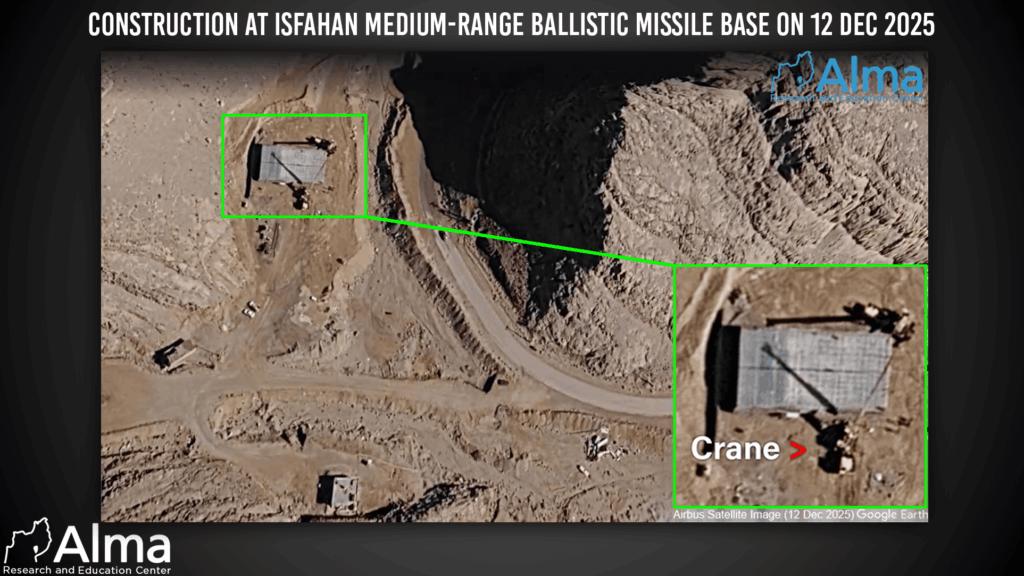
Isfahan West (اصفهان) | 32°42’24″N 51°29’49″E |
Kangavar (کنگاور) | 34°26’31″N 47°52’26″E |
Khorromabad (خرم آباد) | 33°33’09″N 48°12’51″E |
Tabriz North (تبریز) | 38°15’07″N 46°07’33″E |
Shiraz North (شیراز) | 29°43’23″N 52°33’28″E |
Moderate above-ground damage – Between 10% and 50% of the above-ground structures were destroyed:
Zanjan (زنجان) | 36°44’44″N 48°26’20″E |
Yazd (یزد) | 31°48’14″N 54°17’54″E |
Dezful (دزفول) | 32°36’47″N 48°19’42″E |
Qom (قم) | 34°56’38″N 50°45’33″E |
Ahbar (ابهر) | 36°05’12″N 49°13’36″E |
Urmia (ارومیه) | 37°38’24″N 45°12’23″E |
Kermanshah (کرمانشاه) | 34°26’06″N 47°11’22″E |
Light above-ground damage – Less than 10% of the above-ground structures were destroyed:
Shiraz South (شیراز) | 29°28’08″N 52°29’28″E |
Ghazanchi (قزانچی) | 34°28’48″N 47°00’53″E |
Scope of Reconstruction:
Near-zero reconstruction – No new structures built above ground; at most, excavation activity is noticeable:
Zanjan (زنجان) | 36°44’44″N 48°26’20″E |
Baharestan (بهارستان) | 32°27’23″N 51°43’25″E |
Mobarakeh (مباركه) | 32°20’30″N 51°39’50″E |
Yazd (یزد) | 31°48’14″N 54°17’54″E |
Dezful (دزفول) | 32°36’47″N 48°19’42″E |
Panj Pelleh (پنج پلی) | 34°21’30″N 47°14’08″E |
Kamijeh (کمیچه) | 34°31’12″N 47°21’19″E |
Tabriz South (تبریز) | 37°58’14″N 46°10’37″E |
Limited reconstruction – The majority of the above-ground structures that were destroyed have not yet been replaced:
Qom (قم) | 34°56’38″N 50°45’33″E |
Ahbar (ابهر) | 36°05’12″N 49°13’36″E |
Isfahan West (اصفهان) | 32°42’24″N 51°29’49″E |
Kangavar (کنگاور) | 34°26’31″N 47°52’26″E |
Khorromabad (خرم آباد) | 33°33’09″N 48°12’51″E |
Urmia (ارومیه) | 37°38’24″N 45°12’23″E |
Kermanshah (کرمانشاه) | 34°26’06″N 47°11’22″E |
Tabriz North (تبریز) | 38°15’07″N 46°07’33″E |
Shiraz North (شیراز) | 29°43’23″N 52°33’28″E |
Minimal – Only one above-ground structure lost at most:
Shiraz South (شیراز) | 29°28’08″N 52°29’28″E |
Ghazanchi (قزانچی) | 34°28’48″N 47°00’53″E |
Not attacked:
Khorgo (خورگو) | 27°31’41″N 56°27’08″E |
Khormuj (خورموج) | 28°40’30″N 51°26’49″E |
Jam (جم) | 27°47’45″N 52°19’15″E |
Lar (لار) | 27°38’36″N 54°15’23″E |
Borazjan (برازجان) | 29°15’36″N 51°17’03″E |
Hajiabad (حاجی آباد) | 28°19’43″N 55°56’30″E |