By: Colin David and Tal Beeri
General
Operation Northern Arrows began on September 27, 2024, with a wave of IDF strikes against Hezbollah’s underground command center in the Dahieh of Beirut, aimed at decapitating Hezbollah’s leadership.
After Hezbollah leader Hassan Nasrallah was eliminated in the strike on September 27, Hezbollah began executing its transition procedures for full-scale war against Israel.
The IDF carried out extensive waves of strikes against numerous Hezbollah terror infrastructures known to Israeli intelligence. During the months of September, October, and November 2024, the IDF operated extensively across Lebanon, including intelligence-based strikes against targets in Hezbollah’s stronghold in southern Beirut, also known as the Dahieh.
This current report, which analyzes Hezbollah’s use of human shield tactics in the Dahieh based on IDF strikes during the period, is our second geospatial report analyzing the deployment of Hezbollah in the Dahieh and Hezbollah’s use of human shield tactics.
Our first report was published on July 14, 2026, and covered Operation Roaring Lion which took place from March 2 to April 17, 2026.
Hezbollah systematically embedded its military infrastructure into the heart of the densely populated civilian space in southern Beirut. They did so with the highest concentration specifically in the Dahieh, placing headquarters, weapons depots, launchers, and operatives inside residential buildings and in close proximity to sensitive institutions such as schools, hospitals, religious institutions, and daycare centers. This pattern of operation was designed to provide the organization with cover and to enhance the survivability of its personnel and infrastructure, exploiting its awareness of the IDF’s efforts to minimize civilian casualties.
At the same time, Hezbollah presented Israel with an operational dilemma: avoid striking and allow the military infrastructure to continue operating, or strike at the risk of harming civilians. In the event of casualties and damage to civilian infrastructure, Hezbollah exploits the results and visual documentation for propaganda purposes, to mobilize international pressure against Israel, and to reinforce its “resistance” narrative.
In doing so, the civilian population becomes an inherent part of Hezbollah’s operational strategy. Both as cover and a shield for its military infrastructure and as a tool in the cognitive and political campaign against Israel.
Research Area
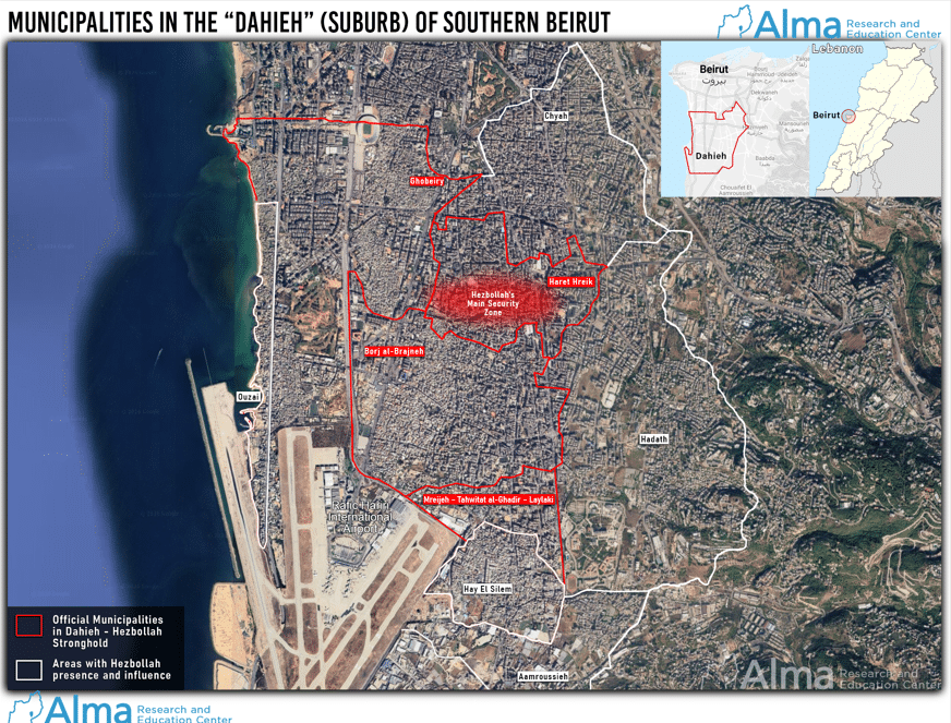
The term “Dahieh”( See our June 2026 article )
, the Arabic word for “suburb”, refers to the predominantly Shia area in southern Beirut that serves as Hezbollah’s main base of operations in Lebanon’s capital. Formally, the Dahieh is represented by the Union of Municipalities of the Southern Suburb (اتحاد بلديات الضاحية الجنوبية), which includes only four municipal units: Haret Hreik (حارة حريك), Al-Ghobeiry (الغبيري), Burj el-Brajneh (برج البراجنة), and Al-Mreijeh – Tahwitat al-Ghadir – Laylaki (المريجة – تحويطة الغدير – الليلكي). These are the municipalities that officially constitute Dahieh.
However, from an urban-geographic perspective, as well as in public, media, and research discourse, the term “Dahieh” is often used to describe a broader urban area located south of the city of Beirut that includes four additional regions. Within this framework, areas such as Hayy al-Sallam (حي السلم) and Al-Ouzai (الاوزاعي) are included, even though they are not part of the official Union of Municipalities.
Additionally, areas like Al-Chyah (الشياح) and Al-Hadath (الحدث) are also not considered a formal part of the Dahieh, but parts of them are sometimes included in geographical and planning descriptions of the space due to their continuous built-up layout and close urban ties with the formal Dahieh areas. The Al-Amrousiya (العمروسية) area is not considered part of the Greater Dahieh region, but Hezbollah presence and influence exist there as well.
Hezbollah’s main security zone is located in the area where the neighborhoods of Haret Hreik and Burj el-Brajneh meet.
This current report analyzes what was struck and destroyed during 62 days of IDF airstrikes in Beirut during the months of September, October, and November 2024, and verifies military targets that we had previously identified.
For the purpose of the study, two scans covering an area of 25 square kilometers in southern Beirut were analyzed, collected via an Airbus satellite.
The defined search area is located south of latitude 33°52′ N, west of longitude 35°32′ E, and north of latitude 33°50′ N. This area was designated as the Area of Interest (AOI) to allow for the identification of the maximum possible number of Hezbollah targets that were struck and destroyed.
The Study’s Timeframe
The control image of the Dahieh was collected by Airbus on May 4, 2024.
On September 17, 2024, the pager attack was carried out against thousands of Hezbollah operatives across Lebanon, in which explosive charges hidden inside their devices were detonated.
On September 18, a second wave of explosions targeted Hezbollah operatives carrying rigged handheld walkie-talkies.
During the ten days that followed, a series of senior Hezbollah officials were eliminated, culminating in the strike on Hassan Nasrallah’s command bunker on September 27, 2024, and a week later, the elimination of his successor, Hashem Safieddine.
Despite the ongoing fighting in southern Lebanon, Israel ceased the airstrikes in Beirut after 62 days, on November 27, 2024, following a ceasefire agreement reached between the governments of Israel and Lebanon.
The post-operation imagery was collected by Airbus on January 2, 2025, approximately 36 days after the ceasefire came into effect.
Strikes in Beirut Preceding Operation Northern Arrows
Prior to the start of the operation on September 27, 2024, several significant strikes against senior figures and infrastructure were carried out:
- Saleh al-Arouri, Deputy Head of Hamas’s Political Bureau, was eliminated on January 2, 2024, at coordinates 33°51’19.12″N 35°30’49.25″E.
- Fuad Shukr, Hezbollah’s Chief of Staff, was eliminated on July 30, 2024, at coordinates 33°51’11.39″N 35°30’23.49″E.
- Ibrahim Aqil, Head of Hezbollah’s Operations Array, was eliminated on September 20, 2024, at coordinates 33°50’49.05″N 35°31’04.32″E.
- Ibrahim Muhammad Qubaisi, Commander of Hezbollah’s Missile and Rocket Array, was eliminated on September 24, 2024, at coordinates 33°51’39.12″N 35°30’22.38″E.
- Muhammad Hussein Sarour, Head of Hezbollah’s Aerial Unit, was eliminated on September 26, 2024, at coordinates 33°50’55.42″N 35°31’00.00″E.
- Hezbollah Leader Hassan Nasrallah was eliminated on September 27, 2024, at coordinates 33°51’05.14″N 35°30’14.47″E.
Destroyed Targets
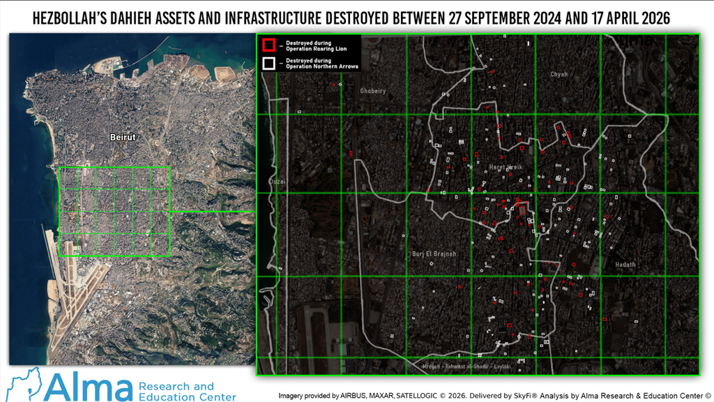
According to the geospatial analysis we conducted, 292 medium and high-rise buildings within the research area were struck and destroyed by the IDF between September 27 and November 27, 2024.
Additionally, 12 low-rise buildings were struck and destroyed, bringing the total number of destroyed buildings within the research area to 304. This figure includes structures where several upper floors were destroyed while the lower floors remained standing.
Many other buildings used by Hezbollah located outside the research area in the Dahieh are known to have been struck by the IDF during Operation Northern Arrows. They are not included in this figure because they fell outside our defined area of interest.
Therefore, the total number of buildings destroyed across the Beirut metropolitan area during the 2024 operation is significantly higher than 304, making this figure effectively a minimum number.
This figure also includes buildings that were so severely damaged that they were subsequently demolished by Lebanese authorities prior to the satellite image capture date on January 2, 2025 (this date represents the post-timeframe status of the current study).
Buildings within the research area that suffered precise strikes but remained structurally intact are not included in this count.
Low-Rise Buildings
12 low-rise buildings that existed prior to Operation Northern Arrows no longer appear in the satellite imagery from January 2, 2025. All of them were located west of longitude 35°31’E.
These buildings were located in dense areas of the Dahieh consisting almost entirely of low-rise structures. Striking them required munitions with low explosive yields and high precision to minimize collateral damage likely 250-pound Small Diameter Bombs (SDB).
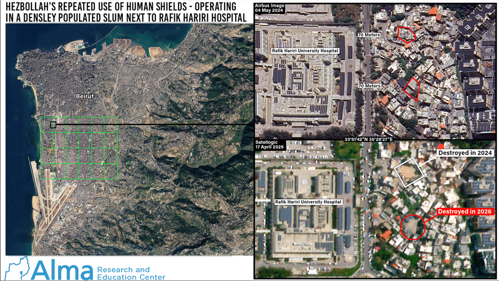
One of the targets was terror infrastructure located less than 90 meters south from the Rafik Hariri University Hospital, in a densely populated urban area.
Two of the low-rise buildings were warehouses:
- A warehouse at coordinates 33°49’59.36″N 35°30’21.57″E.
- A warehouse at coordinates 33°50’34.20″N 35°29’01.43″E, which was used by Hezbollah’s naval unit.
Geospatial analysis findings of the human shield tactics
Through geospatial analysis of Airbus satellite imagery, as well as geolocation of posts on social media, major media outlets, and professional mapping services, Hezbollah assets targeted by the IDF in close proximity to sensitive civilian institutions were identified. Below are several key examples:
Schools
- Hezbollah infrastructure at coordinates 33°50’06.65″N 35°30’36.84″E, located 20 meters from Hussein Maktabi High School.
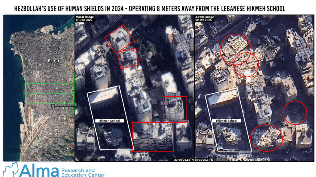
- Hezbollah infrastructure at coordinates 33°50’20.62″N 35°30’37.81″E, located 8 meters from the Hikmeh School.
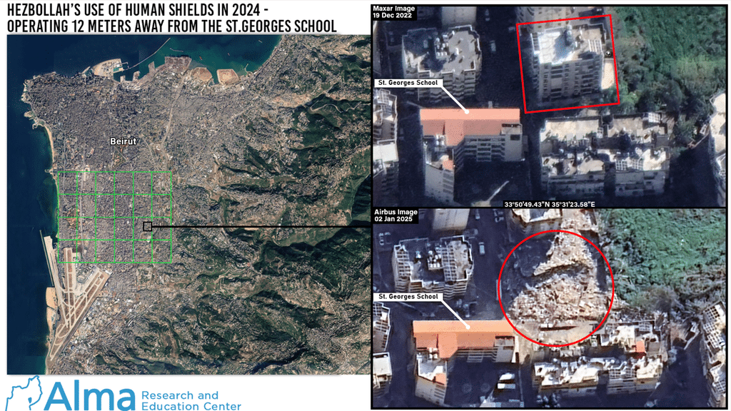
- Hezbollah infrastructure at coordinates 33°50’49.43″N 35°31’23.58″E, located 12 meters from St. George’s School.
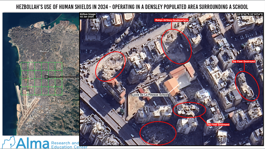
- Hezbollah Unit 4400 infrastructure at the Mahan Airlines headquarters, at coordinates 33°50’38.38″N 35°30’45.32″E, located 14 meters from the Lycée De La Finesse school.
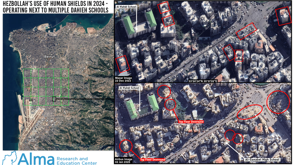
- Hezbollah infrastructure at coordinates 33°50’20.90″N 35°30’59.17″E, located less than one meter from the Al-Sanabel School, inside a densely built-up complex surrounded on all sides by residential buildings and shops.
- Hezbollah infrastructure at coordinates 33°50’24.21″N 35°31’06.51″E, located 20 meters from the Al-Mahdi School.
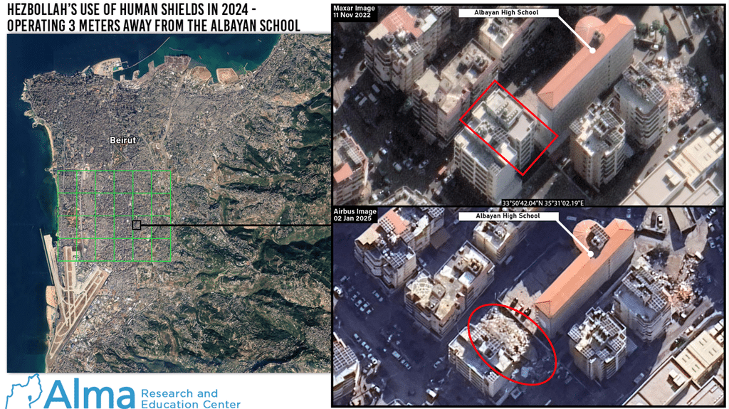
- Hezbollah infrastructure at coordinates 33°50’42.04″N 35°31’02.19″E, located 3 meters from Al-Bayan High School.
Government Buildings and Public Institutions
- Hezbollah infrastructure in a building at coordinates 33°50’03.72″N 35°30’43.01″E, located less than one meter from a Ministry of Telecommunications building.
- Hezbollah infrastructure at coordinates 33°51’42.70″N 35°29’30.80″E, in a dense neighborhood 90 meters from Rafik Hariri University Hospital.
- Hezbollah Unit 4400 infrastructure at coordinates 33°51’53.22″N 35°29’12.81″E, adjacent to Zaraa Hospital, on October 1, 2024.
- Hezbollah infrastructure on the top floor of a building at coordinates 33°50’26.20″N 35°30’28.29″E, adjacent to the Burj el-Brajneh Municipality, on October 6, 2024.
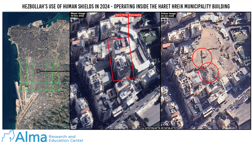
- Hezbollah infrastructure inside the Haret Hreik Municipality building at coordinates 33°50’26.04″N 35°30’28.36″E.
Religious Institutions
- Hezbollah infrastructure at coordinates 33°50’05.29″N 35°30’48.79″E, located less than one meter from a Catholic monastery.
- Hezbollah infrastructure at coordinates 33°50’41.75″N 35°30’28.82″E, located less than one meter from the Amir al-Mu’minin Mosque.
- Hezbollah infrastructure at coordinates 33°50’53.62″N 35°30’45.40″E, located less than one meter from the Imam al-Rida Mosque.
- Hezbollah infrastructure at coordinates 33°51’09.63″N 35°30’46.76″E, located less than 10 meters from the Al-Dahieh Islamic Shia Waqf Committee Center.
The Islamic Shia Waqf Committee and Its Connection to Medium-Range Missile Launch Sites in Beirut
Among other things, several sites were identified as Hezbollah missile storage facilities and launch sites inside and around the Hussein Maktabi High School, the Al-Laylaki Official Co-educational School, and the Al-Burj football stadium, where the Shia Waqf Committee holds land plots.
The “Islamic Shia Waqf Committee in Burj el-Brajneh”—about which we published a separate report—is a social charity foundation that has existed for decades.
Following Operation Northern Arrows, satellite imagery revealed several destroyed buildings near the Hussein Maktabi High School, the Al-Laylaki School, the Catholic monastery, the Al-Burj stadium, and the Ministry of Telecommunications building.
The 2020 intelligence regarding Hezbollah’s weapons storage inside and around the Waqf Committee complex proved to be accurate.
The IDF succeeded in destroying these weapons storage facilities without damaging the sensitive civilian institutions themselves.
Information Gaps and Research Limitations
Buildings within the research area that were targeted with precision, meaning strikes that hit a specific apartment or floor without causing the complete collapse of the structure, are not included in the analysis of this report.
Several buildings used by Hezbollah that were partially struck in this manner were identified in the analysis, but remained standing and appear usable, except for the targeted section.
One structure within the research area was completely destroyed by IDF munitions on March 29, 2025, four months after Operation Northern Arrows. It is possible that the structure was not destroyed during the operation four months earlier either because Hezbollah was not yet using it for military purposes, or because an opportunity to strike it while minimizing collateral damage had not arisen at the time.
Examples of Hezbollah Targets Outside the Research Area
- A Hezbollah surface-to-air missile storage site at coordinates 33°48’43.36″N 35°30’54.63″E, which was destroyed on September 30, 2024.
- Senior Hezbollah logistics operative Muhammad Madi was eliminated at coordinates 33°53’19″N 35°29’39″E on November 17, 2024.
- Airstrike on the Lebanese Ba’ath Party headquarters, in which Muhammad Afif, Hezbollah’s spokesman and head of its media relations unit, was eliminated at coordinates 33°52’59.21″N 35°30’32.26″E on November 17, 2024.
- Four buildings at the northern edge of the Chyah area, on the southeastern side of Horsh Beirut park.
Strikes Against Hezbollah in Beirut After Operation Northern Arrows and Before Operation Roaring Lion
- A strike against an unmanned aerial vehicle (UAV) storage facility of Unit 127 at coordinates 33°50’49.31″N 35°31’16.74″E, on March 29, 2025.
- Hassan Badir, a senior operative in Hezbollah’s Unit 3900, was eliminated at coordinates 33°51’12″N 35°31’01″E, on April 1, 2025.
- A strike against a precision-guided missile storage facility of Hezbollah in the Hadath neighborhood, on April 27, 2025.
- Strikes against underground UAV manufacturing facilities of Unit 127 across the Dahieh, on June 5, 2025.
- Qassem Salah al-Husseini, a prominent arms smuggler for the Iranian Islamic Revolutionary Guard Corps (IRGC) Quds Force, was eliminated in a strike against a vehicle at coordinates 33°47’19.60″N 35°28’47.97″E, on July 3, 2025.
- Hezbollah Chief of Staff, Haitham Ali Tabataba’i, was eliminated at coordinates 33°51’06.70″N 35°30’36.35″E, on November 23, 2025.
Summary and Conclusions
When adding the buildings destroyed in Chyah and Al-Laylaki outside the research area, the number of buildings identified in our analysis as destroyed in the Dahieh during the 62 days of fighting covered in this report (September, October, November 2024) stands at the least 304 buildings.
With the entry into force of the first ceasefire between Israel and Hezbollah on November 27, 2024, Hezbollah began rebuilding its military strength in violation of the ceasefire conditions. In response, Israel continued to strike Hezbollah’s rehabilitation efforts throughout Lebanon.
This pattern of activity by both sides continued for 15 months, until the launch of Operation Epic Fury / Roaring Lion by the United States and Israel in Iran (February 28, 2026).
On March 2, 2026, Hezbollah joined the Iranian retaliatory attacks against Israel.
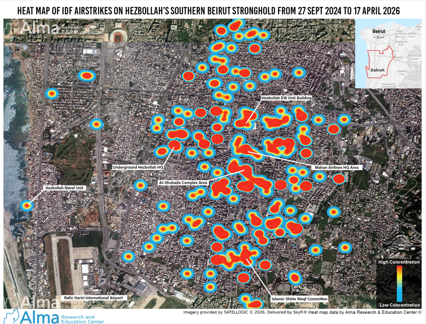
After 47 days (March 2 to April 17, 2026), the IDF destroyed another 62 Hezbollah sites in the same research area in the Dahieh (see summary video of our publication on the subject from July 2026).
According to the analysis, the dramatic drop in the number of Hezbollah targets attacked and destroyed in March and April 2026 points to, in our assessment, a combination of two trends: First, Hezbollah likely struggled to rehabilitate its presence in the Dahieh during the 15 months preceding Operation Roaring Lion (from November 27, 2024) and to restore its military presence to the levels seen in the days prior to the war that broke out in October 2023.
Second, as we have previously published, Hezbollah has been working to redeploy its assets, establishing itself in other areas within the Beirut metropolitan area outside the Dahieh (Which explains the strikes in these areas), as well as in other regions of Lebanon not considered Hezbollah’s ‘natural’ strongholds.
When adding the Hezbollah aerial unit structure destroyed on March 29, 2025, and the structures identified by us as destroyed during Operation Roaring Lion in 2026, the cumulative number of Hezbollah structures that were located and operated in the Dahieh under the cover of human shield tactics and were destroyed between September 27, 2024, and April 17, 2026, stands at 366 buildings (see attached heat map).