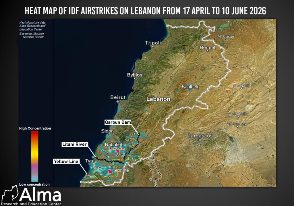
The geographic analysis of airstrikes in Lebanon between April 17 and June 10, 2026, as reflected in the attached heat map, highlights the IDF’s operational focus in southern Lebanon, both south and north of the Litani River. Additional, relatively limited strikes were conducted elsewhere in Lebanon, including the Beqaa Valley, Mount Lebanon, and Beirut.
The most prominent geographic concentrations of strikes in southern Lebanon are located north of the Litani in the Nabatieh area, and south of the Litani in the Tebnine and Tyre areas, as well as east of Tyre in Wadi Jilu. These areas currently constitute key centers of gravity in Hezbollah’s operational deployment along the southern front.
The heat map serves as a geographic indicator of Hezbollah’s activity hubs in southern Lebanon, where Hezbollah infrastructure, capabilities, and threats have been identified. In other words, it reflects significant operational presence by the organization within a given geographic area, whether through weapons storage, militant movement, attempts to rehabilitate infrastructure, observation posts, launch arrays, or other military activities.
Within this context, the activity of Radwan Force operatives is also noteworthy, as they have resumed operations in areas south of the Litani River and, at times, even south of the “Yellow Line.”
The current strike pattern clearly indicates that Hezbollah has been working to restore its military infrastructure south of the Litani River. Analysis of the geographic concentrations suggests that the organization has continued to operate, rehabilitate, and adapt its operational systems in southern Lebanon, while gradually reestablishing its presence in forward areas facing Israel.