
By: Colin David & Tal Beeri
Executive Summary
This research examines the pattern of strikes against Hezbollah infrastructure in the Dahieh area of Beirut during Operation “Roaring Lion” (March–April 2026) through a geospatial analysis based on a comparison of high-resolution satellite imagery acquired before and after the operation, supplemented by verification using open-source information. The objective of the research is to assess the extent and characteristics of Hezbollah’s use of the “human shield” tactic.
The findings indicate that at least 60 civilian buildings used by Hezbollah were attacked and destroyed during the 47-day period of fighting within the geographical scope of the study. These buildings housed significant military infrastructure, including command centers, weapons storage facilities, logistical installations, infrastructure associated with the Radwan Unit, the Electronic Warfare Unit, Unit 4400, and branches of the Al-Qard Al-Hassan Association that supported the organization’s activities. The analysis is limited to buildings that were completely destroyed and excludes precision strikes as well as buildings that sustained only partial damage.
The research further shows that 59 of the 60 buildings were located within or immediately adjacent to densely populated civilian areas, with the distance between them and residential buildings or civilian institutions being, in most cases, only one to ten meters. Only one structure was identified in an open area, far from civilian buildings. Most of the infrastructure was located near schools, hospitals, kindergartens, centers for children with special needs, mosques, gas stations, commercial areas, and public buildings. Cross-referencing all the data indicates that these are not isolated incidents but rather a systematic and continuous pattern of operation.
Analysis of Hezbollah’s operational pattern indicates that it employs two principal methods as part of its human shield tactic: the first is concealing military infrastructure within the civilian population in order to increase its survivability and make it more difficult to attack; the second is the deliberate placement of military assets adjacent to sensitive civilian institutions, based on the understanding that attacks against them may create collateral damage, increase diplomatic and international pressure on Israel, and serve the organization’s propaganda mechanism.
The research further indicates that the strikes carried out by the Israel Defense Forces (IDF) were characterized by a surgical nature and focused on targets of high military value that could not be destroyed through limited munitions or precision strikes alone. The strikes employed munitions intended to collapse the entire structure and destroy the infrastructure concealed within or beneath it, while advance warnings were issued to the civilian population in accordance with international law.
Hezbollah continues to implement a systematic, deliberate, and institutionalized policy of using the civilian population as a human shield as an integral part of its military doctrine. The integration of military infrastructure into the heart of the civilian environment is not an isolated anomaly but rather a central component of the organization’s combat doctrine, intended to improve the survivability of its assets, restrict the IDF’s operational freedom, and exploit the humanitarian consequences of combat for perception, political, and propaganda purposes.

General
Operation “Roaring Lion” commenced on 28 February 2026 with a wave of Israeli Air Force strikes against the Presidential Compound in Tehran, aimed at striking at the leadership of the Islamic Republic of Iran. Following the elimination of Supreme Leader Ali Khamenei, Hezbollah joined the fighting on 2 March by launching rockets toward northern Israel. In response, the IDF initiated a broad aerial campaign against Hezbollah infrastructure in southern Beirut, centered on the Dahieh area.
This research examines the scope and patterns of attacks against, and the destruction of, Hezbollah infrastructure embedded within civilian buildings in the Dahieh during Operation “Roaring Lion”, covering the 47-day period of hostilities through the entry into force of the Israel–Lebanon ceasefire on 17 April 2026. Based on a geospatial analysis of the extent and pattern of the strikes, the research assesses the extent of Hezbollah’s use of the “human shield” tactic.
The analysis is based on a comparison of high-resolution satellite imagery collected by the Satellogic Earth-observation company, before and after the operation, with the objective of identifying and verifying the targets that were attacked and destroyed.
Research Methodology:
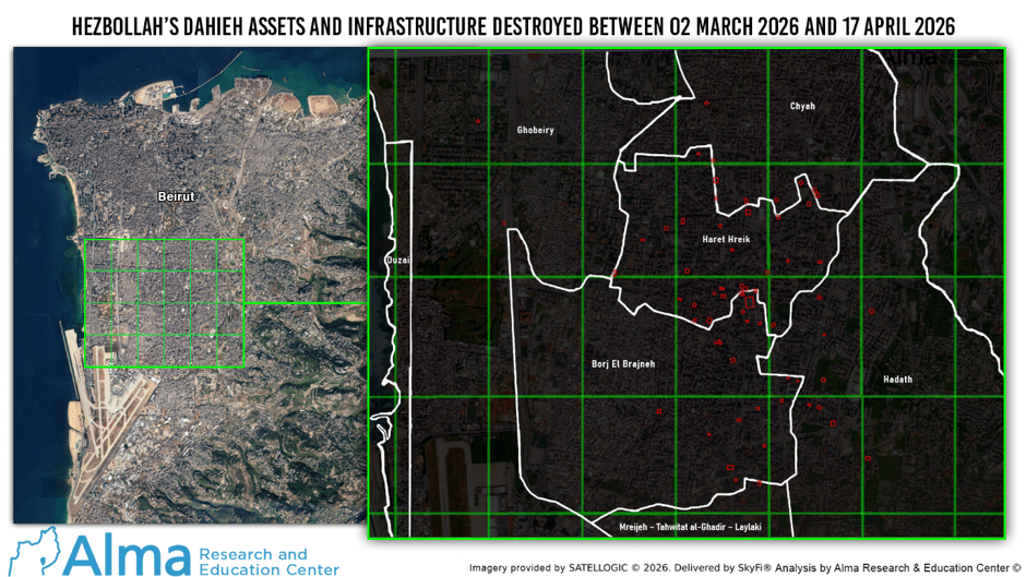
The research was based on satellite imagery covering an area of approximately 25 square kilometers, encompassing most of the Dahieh district. This area constitutes one of Hezbollah’s principal military centers of gravity and serves as the organization’s military, intelligence, and logistical center of activity in Beirut.
(Note – The search area was defined as south of latitude 33°52′ North, west of longitude 35°32′ East, and north of latitude 33°50′ North.)
The reference image was taken on 3 January 2026 (before Operation “Roaring Lion”), while the post-conflict image was taken on 17 April 2026, the day on which the ceasefire entered into force.
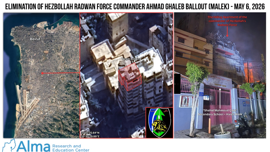
Note – It should be noted that, although following 17 April and up to the time of writing, Israel carried out an additional four strikes in Beirut (see Appendix A), these were surgical strikes that do not significantly alter the analysis and assessment presented in this research (with regard to the total number of destroyed buildings). The most prominent of these was the elimination of Radwan Unit commander Ahmad Ballout on 6 May 2026. As expected, these strikes once again exposed Hezbollah’s cynical use of the human shield tactic. The safe house in which he was eliminated was located in a building adjacent to a school.
As part of the analysis presented in this research, a comparison was conducted between the two satellite images, while cross-referencing the findings with open sources, media reports, IDF publications, and additional geographical information derived from publicly available material.
The Targets That Were Attacked and Destroyed:
According to the geospatial analysis we conducted, at least 60 civilian buildings used by Hezbollah were attacked and destroyed between 2 March and 17 April 2026 within the geographical area of the research.
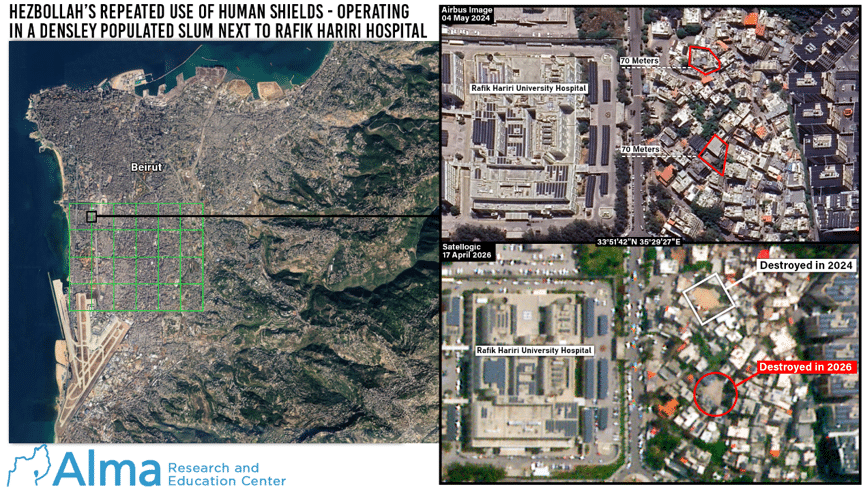
All of the buildings attacked and destroyed during Operation “Roaring Lion” were multi-story or high-rise buildings that contained Hezbollah military infrastructure within or beneath them, with the exception of one single-story structure, located less than 70 meters from Rafik Hariri University Hospital, inside a densely populated neighbourhood.
The analysis we conducted includes only buildings that were completely destroyed (demolished) and does not include:
- Buildings that were partially damaged but remained structurally stable.
- Buildings that sustained severe damage and are expected to be demolished in the future.
- Precision strikes in which only individual apartments or specific floors were destroyed.
Compared with Operation “Northern Arrows” (which began in September 2024), during which hundreds of Hezbollah sites were attacked and destroyed over approximately 60 days of combat (a separate analysis will be published in due course), the strikes conducted in the Dahieh were more limited in scope. However, the available evidence suggests that they were concentrated on targets of high military significance and operational value.
Nature of the Strikes:
The analysis we conducted indicates that the strikes were carried out in a surgical manner.
In most cases, the munitions were directed at the structural support beams of the buildings in order to cause their complete collapse and destroy the military infrastructure concealed within or beneath them.
In accordance with international law, the IDF issued advance warnings to residents of the area prior to the strikes, even though it was evident that Hezbollah operatives would also receive those warnings.
The analysis further indicates that the buildings selected for attack and destruction contained significant Hezbollah military terrorist infrastructure that could not be destroyed through the use of smaller munitions (such as a GBU-39 bomb) or by precision strikes alone.
It should be noted that many additional buildings used by Hezbollah throughout the Dahieh and Beirut were struck using smaller munitions. Consequently, they are not included in the total number of destroyed buildings and were excluded from this study, as satellite imagery indicates that they remained largely intact.
Types of Targets That Were Attacked and Destroyed:
Among the infrastructure identified (see details in Appendix B):
- Facilities that may be associated with Unit 4400, which is responsible for the smuggling of weapons.
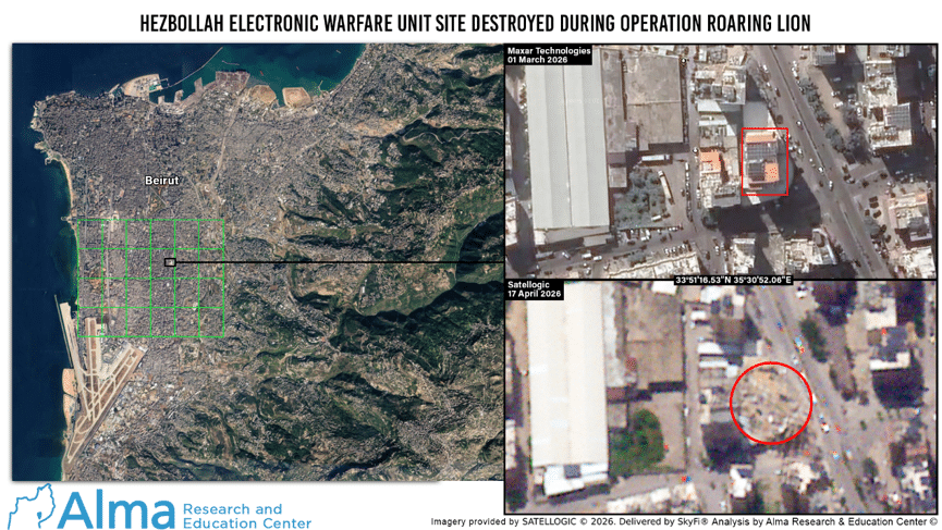
- Facilities belonging to Hezbollah’s Electronic Warfare Unit.
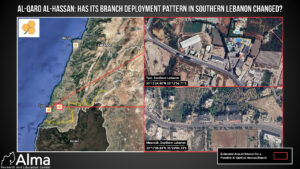
- Branches of the Al-Qard Al-Hassan Association, which, according to the report, also served the organization’s activities.
- Command centers and weapons storage facilities.
- Logistical infrastructure and buildings used by the Radwan Unit.
Many of the targets were located inside civilian buildings or in their immediate vicinity while employing the human shield tactic.
The Use of the Human Shield Tactic:
Hezbollah pursues a systematic policy of integrating its military infrastructure into densely populated civilian areas.
Hezbollah has systematically embedded its military infrastructure within civilian neighbourhoods throughout the densely populated Dahieh district.
The neighbourhoods of Haret Hreik, Burj al-Barajneh, and Ghobeiry within the Dahieh area were particularly affected by this pattern of operation.
The residents of the Dahieh are not accidental victims of the war; they were deliberately placed at risk as a consequence of Hezbollah’s tactic of using them as human shields.
The highest concentration of targets was identified around the Sayed al-Shuhada Complex, a central site used by Hezbollah.
The complex covers an area of 6,158 square meters and was the largest target, by surface area, attacked within the study area during the two operations.
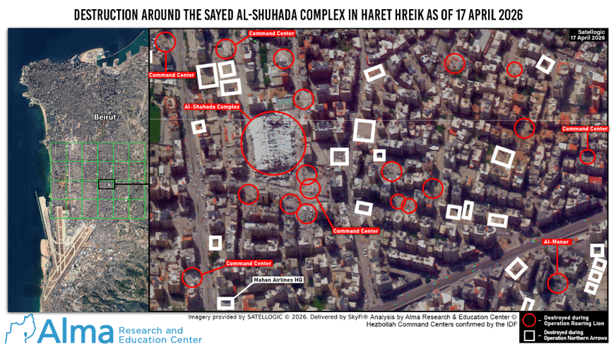
According to the analysis, Hezbollah consistently locates:
- Command centers;
- Missile and weapons storage facilities;
- Operational headquarters;
- Logistical infrastructure;
adjacent to, inside, or beneath residential buildings, schools, hospitals, private businesses, and public buildings.
There are two principal operational patterns associated with the human shield tactic:
The first is the concealment of military activity within the civilian environment in order to make targets more difficult to detect, increase their survivability, and restrict the IDF’s freedom of action.
In the event of an IDF strike, the resulting collateral damage serves to attract international attention, strengthen support among the organization’s support base, and preserve the legitimacy of the “resistance.”
The second pattern is the deliberate location of military terrorist infrastructure adjacent to sensitive civilian institutions (such as hospitals, schools, etc.), with the objective of increasing the risk of civilian casualties and generating diplomatic and international pressure on Israel through propaganda based on the attack and the resulting images of destruction.
Hezbollah understands the asymmetrical advantage inherent in exploiting the cognitive impact of an event with humanitarian consequences against a militarily superior adversary, with the objective of influencing the outcome of the conflict in favor of the weaker force.
Proximity to Civilian Institutions:
Through a geospatial analysis of Satellogic satellite imagery, combined with verification of locations published on social media, in major media outlets, and through professional mapping services, we verified that Hezbollah infrastructure attacked by the IDF had been deliberately located adjacent to sensitive civilian institutions, with the intention of creating high-profile incidents involving civilian casualties in the event of an attack.
The research presents a series of examples (see Appendix C) of Hezbollah targets established in close proximity to civilian institutions, including:
- Hospitals;
- Schools;
- Kindergartens and daycare centers;
- Centers for children with special needs;
- Mosques;
- Gas stations;
- Commercial areas;
- Densely populated residential neighbourhoods.
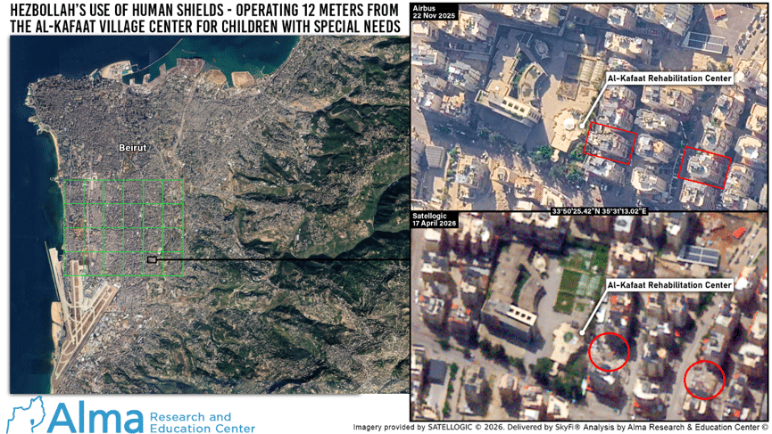
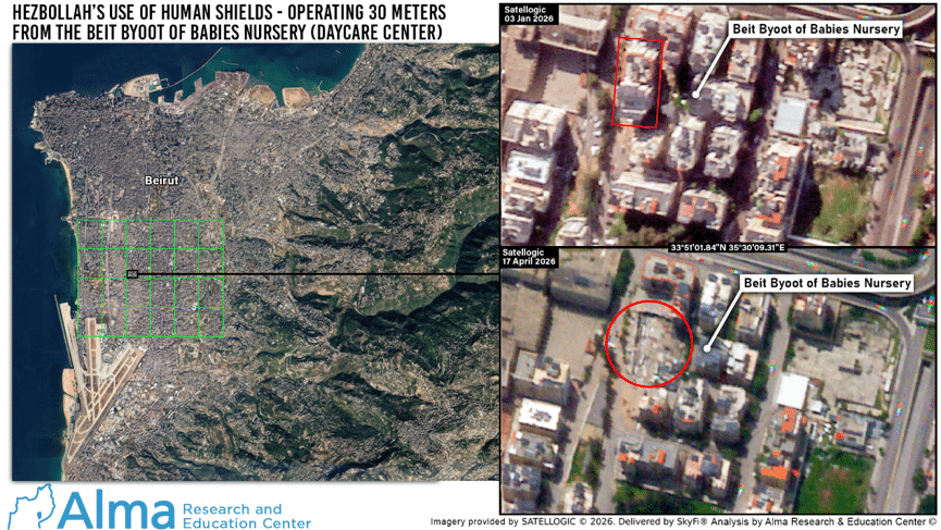
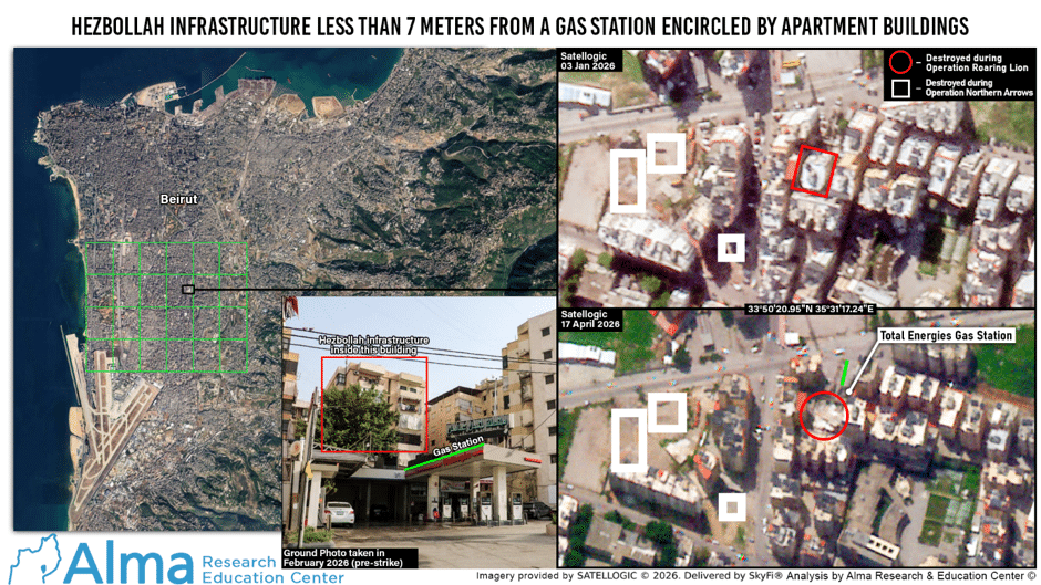
Cross-referencing the satellite imagery with open sources demonstrates that this is a systematic operational pattern rather than isolated incidents.
Among the 60 buildings confirmed as Hezbollah military terrorist targets, only one building was not located adjacent to civilian structures (located at coordinates 33°50’32.41″N, 35°31’14.45″E).
The building stood in an open area, approximately 600 meters from the nearest structure, and was disguised as a civilian advertising and signage company named SIGNDOM.
All of the remaining buildings were either physically connected to civilian structures or located at an average distance of only one to ten meters from them.
Limitations of the Research:
- The analysis relates only to the predefined research area.
- Strikes carried out outside this area are not included (see examples in Appendix D).
- Precision strikes that resulted in the destruction of only a specific apartment or a single floor, without causing the collapse of the entire building, are not included in the count of destroyed buildings examined in this research.
- The data are based solely on satellite imagery collected up to 17 April 2026.
Summary
The research indicates that at least 60 buildings used by Hezbollah were attacked and destroyed in the Dahieh during Operation “Roaring Lion” (March–April 2026). These buildings contained significant Hezbollah military terrorist infrastructure, including command centers, weapons storage facilities, logistical installations, and infrastructure belonging to specialized units.
Fifty-nine of the 60 buildings that were attacked and destroyed were located within or immediately adjacent to the civilian environment, either physically connected to civilian buildings or situated directly beside them, with the distance between them and civilian structures averaging between one and ten meters.
The overwhelming majority of the buildings were located only a few meters from schools, hospitals, public institutions, and residential buildings.
Hezbollah continues to implement a systematic and deliberate policy of embedding its military assets within the civilian population, using civilian buildings and public institutions as an integral part of its operational doctrine.
This operational pattern is intended to make military targets more difficult to attack, increase their survivability, and exploit the humanitarian consequences and collateral damage resulting from attacks against them for cognitive and political purposes.
The IDF employed extensive measures to ensure that its operations were directed exclusively against legitimate military objectives. However, when a terrorist organization deliberately embeds its military assets within the civilian population, collateral damage cannot be entirely avoided.
Hezbollah’s strategy is not intended to protect the civilians of Lebanon, but rather to exploit them as human shields in the course of its war against Israel.
Appendices
Appendix A – Surgical Strikes in Beirut
Following the ceasefire on 17 April, the IDF carried out four surgical strikes in Beirut:
- The elimination of Hezbollah Radwan commander Ahmad Ballout, at coordinates 33°51’21.23″N, 35°30’29.25″E, on 6 May 2026. The apartment in which he was hiding was located in a building adjacent to a school.
- The strike against Ali al-Housni, commander of the Imam Hussein Division’s Missile Array, on 28 May 2026.
- The strike against a Hezbollah command center, at coordinates 33°50’56″N, 35°30’56″E, on 7 June 2026.
- The strike against another Hezbollah command center, at coordinates 33°51’31.9″N, 35°30’30.1″E, on 14 June 2026.
Appendix B – Examples of the Types of Targets Attacked
- A building that may be associated with Hezbollah’s Unit 4400, located in the Shipbrands company building, at coordinates 33°51’24.07″N, 35°31’09.25″E, only 12 meters from the 1 Club Gym fitness club and physically connected to residential buildings.
- A building that may be associated with Hezbollah’s Unit 4400, located in the Cargo WTB building, at coordinates 33°51’03.80″N, 35°31’04.24″E, only four meters from the Haret Hreik Sports Club, and physically connected to residential buildings.
- Hezbollah’s Electronic Warfare Unit, located at coordinates 33°51’16.51″N, 35°30’52.12″E, positioned directly above numerous private businesses.
- A branch of the Al-Qard Al-Hassan Association, located at coordinates 33°51’21.09″N, 35°31’13.21″E, on the main road and only six meters from a nearby office building that was also used by Hezbollah.
- Another branch of the Al-Qard Al-Hassan Association, located at coordinates 33°50’10.11″N, 35°30’44.56″E, 10 meters from Al-Burj Football Stadium and adjacent to residential buildings.
Appendix C – Examples of the Location of Hezbollah Sites Near Sensitive Civilian Institutions
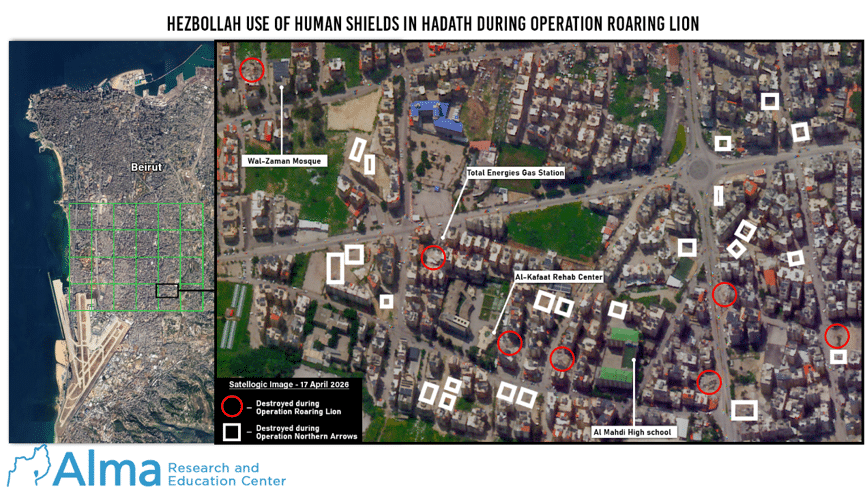
- A Hezbollah infrastructure site at coordinates 33°50’25.42″N, 35°31’12.80″E, located only 10 meters from the Al-Kafaàt Foundation Center for children with special needs.
- A Hezbollah infrastructure site at coordinates 33°51’01.95″N, 35°30’09.09″E, located 30 meters from the Beit Byoot of Babies children’s nursery.
- A Hezbollah infrastructure site at coordinates 33°50’42.08″N, 35°30’41.43″E, located 15 meters from the S&P clothing factory.
- A Hezbollah infrastructure site at coordinates 33°50’38.38″N, 35°30’45.32″E, located only 10 meters from Al-Adab Secondary School.
- Another Hezbollah infrastructure site at the same coordinates (33°50’38.38″N, 35°30’45.32″E), positioned within a dense block of buildings and surrounded on all sides by residential buildings and shops.
- A Hezbollah infrastructure site at coordinates 33°51’42.28″N, 35°29’27.59″E, located within a densely populated neighbourhood and only 70 meters from Rafik Hariri University Hospital.
- A Hezbollah infrastructure site at coordinates 33°50’11.78″N, 35°31’27.60″E, located 20 meters from the Saheb Al-Asr Wal-Zaman Mosque.
- A Hezbollah infrastructure site at coordinates 33°50’20.68″N, 35°31’16.91″E, located 10 meters from a TotalEnergies gas station and surrounded by residential buildings.
- A Hezbollah infrastructure site at coordinates 33°51’13.40″N, 35°30’24.91″E, located 50 meters from Bahman Hospital.
Appendix D – Examples of Targets Attacked Outside the Geographical Area of the Research
- A strike on a meeting of Hezbollah and Islamic Revolutionary Guard Corps personnel at the Hotel Comfort, located at coordinates 33°50’57.74″N, 35°32’28.02″E, on 4 March 2026.
- A strike on an apartment in the Hazmieh area, where a senior Islamic Revolutionary Guard Corps official was staying, on 23 March 2026.
- The elimination of personnel from the Lebanon Corps and the Palestine Branch of the IRGC Quds Force at the Ramada Hotel, located at coordinates 33°53’29.58″N, 35°28’21.71″E, on 7 March 2026.
- A strike at the Cola Junction, located at coordinates 33°52’56.59″N, 35°29’36.32″E, on 8 April 2026.
- Numerous targets in northern Beirut, attacked as part of Operation “Eternal Darkness” on 8 April 2026 (see the analysis of the strike against dozens of Hezbollah core military targets on 8 April).


2 Responses
Dear Colin and Tal,
Thanks for the documented evidence of the human shields policy of hezbollah. But the required solution is the elimination of the parasitic cancerous hezbollah tumors entirely. Your analysis is like the medical test that proves the presence of the radical disease. Now every cell must be destroyed.
Thank you as always for this comprehensive explanation of what is happening in Lebanon . Shameful activity by Hezbollah thank you for all you are and all you do to help Israel. Stay safe