
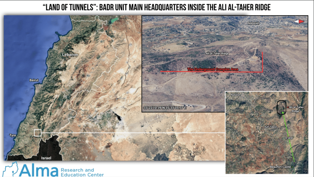
Over the past several days, the IDF has been carrying out a necessary offensive operation on the Ali al-Taher ridge, which in effect serves as a lower-elevation topographical extension of the Beaufort Castle ridge to the northwest.
In the area where the IDF is conducting ground operations on the Ali al-Taher ridge, located approximately 4.5 kilometers northwest of Beaufort Castle in a straight line and north of the village of Tebnine, Hezbollah built, most likely with Iranian and North Korean assistance, a massive strategic underground infrastructure complex that currently serves as the main headquarters of the Badr Unit.
The combination of Hezbollah’s loss of control over the Beaufort Castle area and the Ali al-Taher ridge, together with the damage inflicted on its key underground infrastructure, constitutes a blow to a major center of power that Hezbollah invested significant efforts over time to preserve and defend. The Iranians understand this very well, which is why they are leveraging threats to halt negotiations with the United States and even to close the Strait of Hormuz.
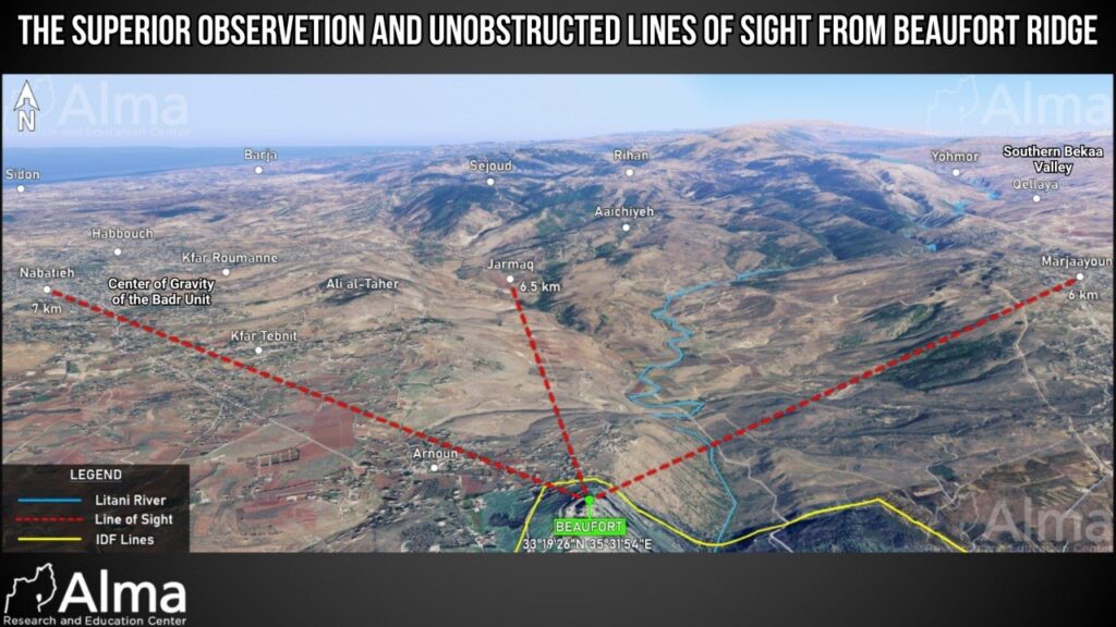
Today, the Badr Unit is the most significant and central Hezbollah unit operating against IDF forces in southern Lebanon. The area around the city of Nabatieh, located west of the Ali al-Taher ridge, serves as a key operational center of gravity for Hezbollah’s deployment in southern Lebanon. Over many years, strategic underground infrastructure was constructed on the Beaufort Castle ridge (which is currently under IDF control) and on the adjoining Ali al-Taher ridge, both of which have been designated by Israel as areas within the Yellow Line.
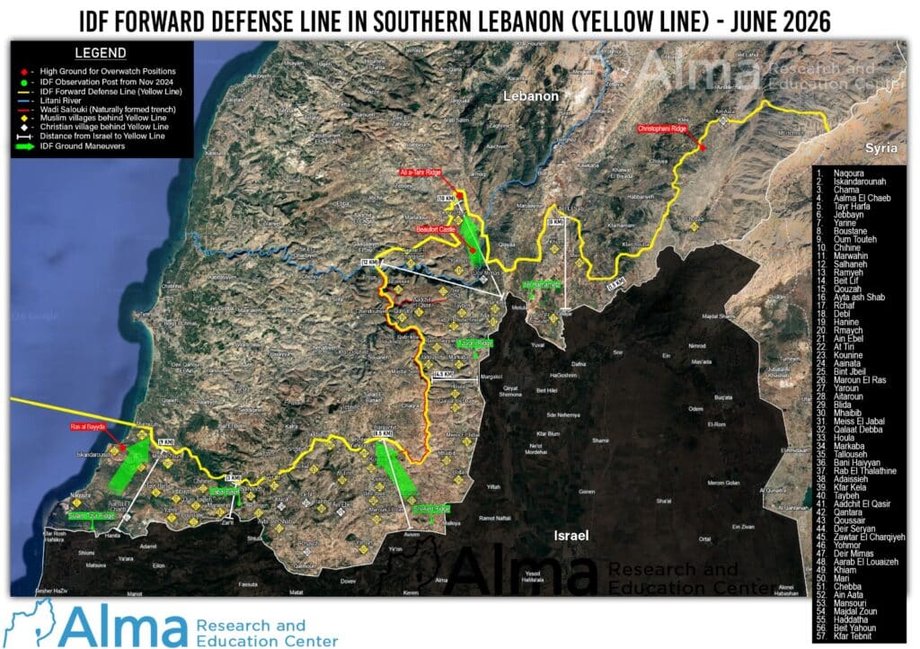
The IDF is currently conducting ground operations on the Ali al-Taher ridge against the Badr Unit’s primary underground infrastructure, located approximately 10 kilometers from the Israeli border near Metula. This facility serves as the main headquarters of the Badr Unit and, in all likelihood, can be used to launch weapons and conduct attacks into Israeli territory. The infrastructure includes several underground sub-complexes, the largest of which extends for more than one kilometer.
It can be assessed that, similar to other underground facilities exposed in recent years, this complex contains underground command-and-control rooms, weapons and supply depots, field clinics, and dedicated launch shafts used for firing various types of missiles, including rockets, surface-to-surface missiles, anti-tank missiles, and anti-aircraft missiles. These shafts are concealed and camouflaged, making them undetectable from above ground. In addition, the tunnel network enables the movement of forces from one location to another for reinforcement or offensive operations in a secure, protected, and concealed manner. It is possible that some sections of the tunnel system are large enough to accommodate motorcycles, all-terrain vehicles, and other small vehicles.
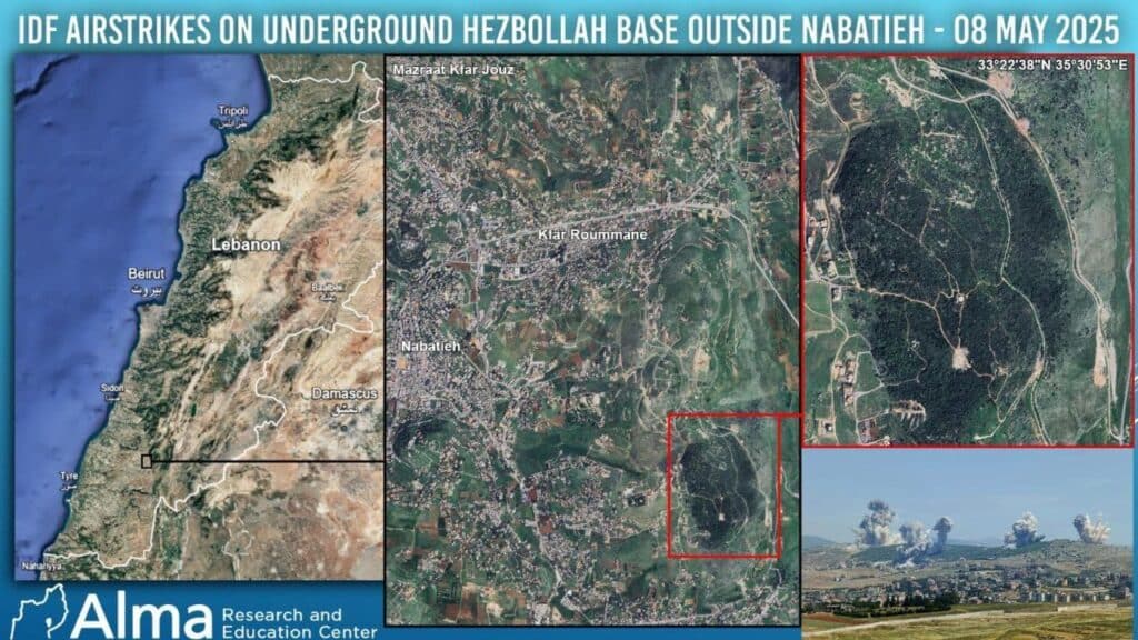
It should be noted that during May and June 2025, the area containing this infrastructure was targeted from the air at least three times. However, those strikes failed to destroy it, and Hezbollah subsequently restored and rehabilitated the facility. As of the time of writing, dozens of Hezbollah operatives are reportedly surrounded within the underground complex.
Until the outbreak of the war in October 2023, the area north of the Litani River, under the control of the Badr Unit, was designated by Hezbollah as the “Second Line of Defense” in southern Lebanon. The area south of the Litani, meanwhile, was designated as the “First Line of Defense” and was under the control of the Nasr and Aziz units.
The underground infrastructure on the Ali al-Taher ridge was built in the years following the Second Lebanon War (2006) as part of Hezbollah’s Second Line of Defense in southern Lebanon and within the framework of Hezbollah’s “Land of Tunnels” project, which was implemented throughout Lebanon in general and southern Lebanon in particular, with assistance from North Korean and Iranian personnel (see the special report we published in July 2021 on Hezbollah’s “Land of Tunnels” – the North Korean-Iranian Connection).
According to various testimonies and indications, Hezbollah carried out and/or planned underground construction projects in numerous geographic areas across southern Lebanon through the Jihad al-Binaa Association. These activities were supervised by North Koreans (most likely advisers from the North Korean company KOMID) and officers from Iran’s Islamic Revolutionary Guard Corps, most notably the military engineer Hassan Shateri, also known as Hessam Khoshnevis, who was killed in Syria in February 2013.
The Jihad al-Binaa Association relied on Shiite-owned civilian engineering and contracting companies, which served as civilian cover for the construction of the “Land of Tunnels.”
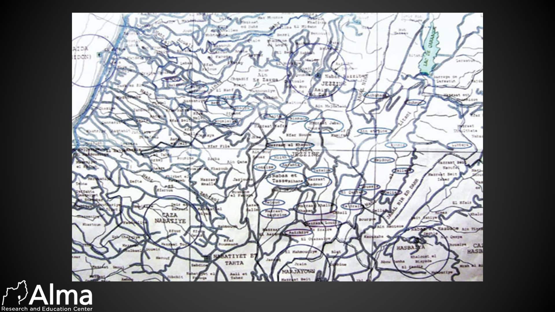
We possess a 2008 map of southern Lebanon covering the geographic area between Sidon in the west, Lake Qaraoun in the east, and Marjayoun and the Nabatieh region in the south, including the Ali al-Taher ridge. On the map, an unknown party marked polygons (circles) around approximately 36 geographic areas and localities.
In our assessment, it is highly likely that the map depicts the planned construction layout of the “Land of Tunnels” — Hezbollah’s underground infrastructure and fortification network in southern Lebanon.
Photograph of the original map (the Nabatieh area is the large polygon in the lower-left section):



One Response
Dear Tal,
The ayatollah-IRGC-hezbollah axis of evil death cult ideology and genocidal war objectives have clearly been openly displayed for anyone who wants to see the truth. Many are willingly ignorant, turning a blind eye to advance their own selfish interests. Justice must be executed. This means the total annihilation of this three headed snake must now be executed.